Sunday, 6 April 2014

Aussie and Out

We can barely believe it, but we have now left Australia and effectively started our journey home. So, let us tell you about the last couple of weeks of our time in Oz.


On Saturday 15th March, we headed back from our week's sojourn in the Blue Mountains. On the last day there, Sue had been bitten/stung on her foot by an unidentified insect and we had a few worried hours where we contemplated calling an ambulance, as her leg swelled up. We spoke to the reception of the camp site and they gave a typical Aussie response: a shrug of the shoulders and 'She'll be right - you'd be dead by now if it was anything serious'. Fortunately it went down without any more medical intervention than some anti-histamine, but it was still painful as she hobbled up to Blackeath station for the train back to Sydney. We still don't know what it was that bit/stung her, but there was only a single puncture mark on her foot (which is still visible now), so we suspect that it wasn't a spider.

From Sydney, we jumped on a flight to the Sunshine Coast with Jet Star. Alongside the Hello World travel agency, they are one of two Aussie corporations that we will most definitely not miss. Anyone considering using either of them, should watch out for some of the most misleading advertising / terms and conditions that you will ever find!

But onto more positive things. From the Sunshine Coast, we had decided to book a car for 11 days to allow us more freedom for the journey up the coast to Cairns. Our first stop driving north, was Noosa a pleasant town, with some beautiful stretches of beach and an area of national park, with some great cliff top walks.

I took a swim on Sunshine Beach, which was less a swim than a battle to stand against the huge waves that pounded in off the Pacific. Life guards watched like hawks from the shore and I took the hint that going in past waist deep was probably not sensible. This would be the last beach swim that I would take in Australia, because further north there are dangerous box jelly fish at this time of year that can deliver fatal stings (how many poisonous/life threatening creatures are there exactly in Australia? We've lost count!)

Deciding that surfing here was probably best as a spectator sport, we took a long walk along the beach and up a steep path that led to the Noosa Heads. From here, we got magnificent views for miles down the coast and watched as the sun set over the ocean.

One of the remote beaches north of Noosa

As we headed out of Noosa, the road felt more and more remote and tropical. There was very little traffic and the road stretched on for miles in the distance through forest and bush. I put the car on cruise control, as the local police are apparently zealous and ingenious in equal measure when it comes to speeding and I was anxious to avoid any unnecessary contributions to the Australian Treasury. At around midday, we passed the town of Gympie. We briefly considered stopping for lunch, but decided it was not somewhere we would want to get tied up for long.

Instead, we continued on to Maryborough, which looked like a tiny spot on the map, but turned out to be quite a large historical market town. It's wide streets were lined with impressively regal Victorian era buildings that shimmered and sweltered in the heat. As we turned a corner though, we stumbled on its main claim to fame: a big statue of Mary Poppins - the author was apparently born and raised here!

After a very poor lunch in a Maryborough pub (even Mary Poppins would have found it tough making this medicine go down), we headed on past the line of the Tropic of Capricorn to our stop for the evening of Agnes Water and the Town of 1770. The area is famous for 2 connected facts: firstly this is the southernmost part of the Great Barrier Reef and secondly was the first landing point in Queensland for Captain Cook (presumably because any further north, his ship would have grounded on the reef) in the year 1770.

We holed up here for a couple of nights and on the following day, I went off for a day's snorkelling to the nearest of the reefs at Lady Musgrave Island - a 90 minute boat trip away. Sadly, Sue didn't feel able to manage a whole day out at sea, so I did it on my own, but at least we had booked ourselves into a decent hotel for the 2 nights.

My boat trip wasn't quite as personal as I would have liked, with about 50 people on board a huge boat that roared out to sea in the direction of the reef, but it was an enjoyable day nonetheless. Lady Musgrave Island is a tiny coral cay, probably no more than an acre in size. It is covered by piscina trees that form an interesting, apparently symbiotic, relationship with a variety of roosting sea birds: the trees provide shelter and shade for the birds, whilst the birds provide fertiliser for the trees. I say apparently, because in years of drought, the tree's leaves dry out and become sticky: inevitably then attaching to the birds feathers and preventing them first from flying and finally paralysing them altogether. Last year was very dry and we saw the corpses of numerous birds, unwittingly now providing food for their shelterers. I think it was Milton Friedman who said 'there's no such thing as a free lunch', but I thought he was an economist rather than a botanist!

Although tiny in size, the island is surrounded by a coral wall that is almost exposed at low tide thereby forming a beautiful lagoon to surround the island. As we approached, we could see waves breaking a few hundred metres from the shore and the sea colour changing from dark to azure blue. We spent an hour exploring the island and then had a good couple of hours snorkelling a large area of reef. The marine life wasn't quite as abundant as I was hoping, but I was lucky to swim right over a family of turtles and quite a range of different types of fish with a kaleidoscope of colours, including angel, clown, parrot and butterfly. I swam for hundreds of metres around a wall of coral and at points it was shallow enough to have reached out and touched. There was significant signs of bleaching at points, but at the same time large clusters of healthy, beautifully coloured coral.

Lady Musgrave Island - a coral cay
A barramundi fish, swimming close to the boat
On Wednesday 18th March we continued the journey northwards for a long drive day - about 10 hours of driving all-told. We had decided to break up the coastal scenery, by heading inland just before getting to the industrial city of Mackay for a couple of days in the Eungella National Park. This seemd like a good idea, because we seemed to spend much of the day passing through continuous sugar cane plantation, which paused only briefly in Bundaberg, because this is where they turn the sugar cane into rum!

In the late afternoon, we turned off the main road and, for a while, we seemed to be engulfed on all sides by sugar cane, occasionally crossing small railway lines built to get the crop to market from these remote locations. But the road started to climb gradually so that we could get some perspective and the rolling hills softened the landscape. In the distance we could now see the looming range of the Eungella National Park, one of the largest areas of tropical rainforest in Australia. But also in the distance now, were some pretty menacing storm clouds and we were in a race to get to our destination before nightfall and/or the storm hit.

As dusk started to approach we reached the end of the coastal plain and we started to climb steeply, switchbacking up the mountainside through thick forest. As we ascended, the cloud seemed to descend to meet us, gradually taking away the views back over the sugar cane fields stretching for miles towards the ocean. At times we looked nervously up and down at sheer rock faces, worrying that this looked like prime terrain for rock falls. Fortunately the storm held off until after we arrived at our hotel, though it was pitch black by this time, with not a street light to be seen.

Over the next 36 hours, though, we found out why they call rainforest rainforest - because it rains a lot! Indeed for the duration of our stay here it didn't stop raining, often torrentially and accompanied by howling winds, bending the trees backwards at impossible angles. Our hotel for the next 2 nights was an historic old building and hadn't long reopened after a typhoon had ripped the roof clean off in late 2012. We were upgraded to a supposedly luxurious cabin, but this turned out to be dingy and damp and we couldn't do much but sit and watch the rain drive down, the thick cloud blocking any views, whilst hoping that the new roof would stay attached!

One of the big draws for this area is the presence of duck billed platypus in the rivers. We decided that a potential sighting was worth a soaking and in a brief respite, we made a break for a promising spot by the river, with a viewing platform covered by a canopy of trees. Within 10 minutes of arriving, we got our reward, spotting not just a platypus, but also a family of turtles and an azure kingfisher that darted to and fro across the river, very nearly stealing the show. But the platypus had it, keeping us entranced for ages, disappearing under the water for minutes at a time, then just when we had given up on him breaking to the surface again as if to check whether we were still there. What had been a miserable day, suddenly became memorable.

Surely, no introduction needed!

A turtle and azure kingfisher in the same riverside location at Eungella
After Eungella, we had one more long drive day. We had decided to blast as far as we could (more than 400 miles) to get to Mission Beach and within striking distance from there to Cairns. This would allow us to spend 3 nights and 2 full days in one place: a wonderful looking lodge run by an English couple, with 4 rooms surrounded by beautiful tropical gardens where a family of rare cassowary birds were regular visitors.

But first we had to get there and our drive was punctuated by torrential downpours - some so heavy that we had to stop the car because the wipers couldn't clear the windscreen quickly enough. The further north we went, the heavier the rain seemed to get. This surprised us, because we had heard a few weeks before about serious drought in much of Queensland: this was well and truly over now it seemed.

As we got closer to our destination, the situation started to get more serious. At the town of Tully, shortly before our turn off from the main highway, the road was starting to flood and we found our exit blocked as the road disappeared underwater. As far as we knew, there were only 2 roads in to Mission Beach, so we continued the 20 kms north for the alternative. We were now starting to worry, as the daylight faded and the rain continued to pour down. At the second road, we fared well for a few minutes, until we saw splashing ahead. We slowed and watched as a huge 4wd came slowly through a deep puddle towards us. He wound his window down as we got level, looked us up and down and in typical sarcastic Aussie drawl said 'I wouldn't try and get through there in THAT if I were you' and drove off. THAT, of course, being our poor little hire car!

We turned round and back at the main road called our hosts for the evening. They gave us some directions for an alternative route not even marked on our map. It took us on single track road though with sugar-cane fields on either side, but at least on slightly higher ground. I drove with great trepidation in the near darkness with floodwaters starting to lap at the edge of the road at points. Sue was in a state of some distress when we eventually arrived, but we had arrived safely and now could kick back and relax for a couple of days - there could be far worse places to get stuck then this if it carried on raining!

We decided not to be too ambitious with our couple of days here, so barely left our accommodation: just enjoying the setting, the full-on breakfasts, swimming in the 'jungle pool', reading and writing and talking to our fellow guests (an English women who was there all the time we were, had had the distinction of operating the hawk-eye system at Wimbledon during the London Olympics and caused the wrath of Andy Murray when she couldn't work out how to turn the screen off during rallies!). We also kept an eye out for the occasional visit of a cassowary, but sadly this never coincided with our camera being nearby - if you google them, you will see how striking they are and also why we treated them with a lot of respect!

Our oasis at Mission Beach for 3 days...
...almost halfway between New York and London - and not forgetting Sevenoaks!

The morning after the storm, on Mission Beach

After 3 nights here, the rain had stopped for long enough to let the floodwaters subside and we made a break for Cairns. The Holiday Inn was running a 3 day special and as this coincided with my birthday, we decided to go more up-market than our norm. Cairns has a mixed reputation, with some finding it rather bland and only useful as a base for diving on the Barrier Reef. We quite enjoyed it though, despite arriving in the heaviest rainfall here in more than 2 years. Although there is no beach here, the sea-front is quite lively with people walking up and down at sunset and they have built an artificial beach and lagoon at one end. As we walked past the lagoon on our first evening, a mass aqua-aerobics session was underway, with hundreds of scantily clad tourists jumping up and down in the water to the strains of YMCA by Village People - priceless!

On our final day in the area, we drove a big loop of the Atherton Tablelands, a forested plateau full of dramatic waterfalls and remote villages in the Cairns hinterland. In the evening, in honour of entering my fiftieth year, we treated ourselves to dinner in a sea-food restaurant. It was probably one of the first decent meals that we have had in our 4 months in Australia, that wasn't either Thai, or cooked by one of our friends/family!

One of many dramatic waterfalls on the Atherton Tablelands near Cairns
The famous 'hippie market' in the Atherton Tableland town of Kuranda...
 
Roll over Beethoven - a young boy tinkles the ivories for the shoppers at Kuranda market
Which leads us back to Darwin, our entry and exit point from Australia, with the best part of 4 months in between. Darwin is not one of our favourite places, so we just stopped for one night ahead of our flight out to Bali on the morning of 28th March.
Although we had both been to Australia before, it is easy to forget what a vast country Australia is and how harsh and unforgiving most of it is. The aboriginals adapted to this environment over tens of thousands of years, but the white settlers needed to hard to survive here and even today it must be difficult to thrive away from the main cities.

On this trip, with a decent amount of time, we've managed to see a lot of the eastern half and get under the skin of the country much more than we have managed on previous trips: we've travelled on the ground through the dramatic 'Red Centre'; seen breathtaking scenery, from the sea and cliffs of the Great Ocean Road to the forests of Tasmania and the mountains of the Great Dividing Range; been enchanted (and occasionally frightened) by the unique wildlife here, which we have been hugely fortunate to see in the wild and in their natural settings (kangaroos, wallabies, koalas, possums, bandicoots, echidnas, koalas, kookaburras, parrots, platypus to name a few) and spent some time in Australian cities including Sydney and Melbourne.

Just as importantly, we got to spend some quality time with some of our friends that live here and Sue's family in Melbourne and Canberra. It's a long way here and back (particularly when you do it by road!), so we had to make every moment count.

It was 16 years since our last trip to Australia and it has undoubtedly enriched itself in that time in many ways, including economically, socially and culturally. Although thee remains a special relationship between Australia and the UK (particularly when it comes to beating England at cricket, which I was unfortunate enough to have to witness), the umbilical cord with 'mother England' has been well and truly cut and, if anything Australia takes it's lead now more from the US and Asia.

Economically, success has been fuelled by a global commodities boom, plentiful land, a growing population, free capital and a strengthening relationship with the tiger economies of Asia (nearly a third of Aussie exports go to China, who has voraciously sucked up their resources, as fast as they can be dug out of the ground).

Can this continue? On the one hand, it's singular reliances seem fragile, on the other, why shouldn't it continue, predicated as it is on growing global populations and as the east plays catch-up with the west in their standards of living and quality of infrastructure.

The big elephant in the room though, is whether the earth can sustain these burgeoning populations and lifestyles and this, we think, is where Australia is most vulnerable. It is already seeing the impacts of climate change, with record high temperatures (we experienced 44 degrees in Melbourne and in the centre and it's not fun), forest fires that increasingly encroach on towns and cities, drought, flooding, typhoons and degradation of natural environments. This, it seems, will only intensify and represent an increasingly severe challenge to Australian society.

Anyway, sadly our Australian adventure is now over. It has been a hugely exciting, if sometimes challenging time and we will take many memories with us. As you read this, we are now ensconced on the Indonesian Island of Bali, the 16th country of our journey. In our next post, we will tell you about the start of our journey back into Asia.


Thursday, 27 March 2014

Back in New South Wales

On Monday 3rd March, we had a 5 am start for the flight out of Auckland and before we knew it, we were back in Sydney. The plan was to spend a week here, so that I could have a proper catch up with my old school friends Darran and Martin before starting the journey north, culminating with a flight out of Australia for Bali on 28th March.


As tends to happen at some point on a long journey like this, we were suddenly feeling rather jaded and questioning what we were doing. In an eagerness to see and do everything in Tasmania and New Zealand, I had probably set rather too hectic a schedule for the previous couple of months and we were feeling the need to slow things down a little. We were also becoming acutely aware that we had no plans after this week in Sydney beyond our flight to Bali, so altogether we needed some time-out to take stock.

In the modern-age, to do this one needs the internet, a commodity which is guarded with cummudgeonly zeal in Australia and New Zealand. On our first day in Australia, we had asked in a cafe if they had wireless access and after consulting with the manager, we were reluctantly given 15 minutes complimentary access as if we were being given the Crown Jewels - on this stop in Sydney, even 15 minutes was difficult to find!

On our first time in Sydney in December, we had done a day trip to the Blue Mountains, which wasn't nearly enough, so we decided that after a week in Sydney we would retreat there for a quiet week. We found a place in our guide-book (resorting desperately to 20th century technology) that offered a cabin with a rural setting and wireless internet access!

But first, we had 5 days in Sydney. We based ourselves in Kirribilli, a quirky little suburb lurking under the shadow of the Harbour Bridge on the north shore of the harbour. There are some hugely expensive houses here with great views over the harbour (including one belonging to the Australian Prime Minister Tony Abbott), but also a slightly gritty inner-city feel, with an eclectic mix of people, cafés and shops and a real-sense of community.

It was also interesting to get a different view of the iconic Harbour Bridge. From here, we really appreciated its massive scale, it's stone and steel towering above us. Sue's paternal grandfather was a stone-mason and worked for a while on the bridge's construction, so for her it was particularly poignant standing where he would have stood, seeing his completed handiwork (such an important and long-lasting edifice) and wondering what he would have made of the scene today. There was a lot of information dotted around Kirribilli on plaques charting the effect on the area (much of it had to be demolished to make way) when the bridge was built in the 1920s and 1930s - previously the only way across was a ferry and the town was built on the trade that this brought.

We also took a morning to do a walking tour of the city, taking the little ferry that still chugs across the harbour from Milsons Point to Circular Quay and back. The tour was run by an enterprising young local couple, who slightly disingenuously described it as 'free', but then made very clear that they relied on tips to make a living. We reckon that they do quite well on it, because there were more than 50 people walking round with them, split into 2 groups and they run 3 tours a day! It was an interesting tour nonetheless.

Looking back over Sydney Harbour from Kirribilli

I enjoyed the time catching up with my old school friends Martin and Darran. We travelled together in 1989/90 and Martin never returned, whilst Darran went back for good 10 years later. Maybe they expected us to stay as well, but Australia doesn't quite work for us the way it does for them. Anyway, we got a couple of rounds of golf in (including a final hurrah when they drove up to the Blue Mountains) and a couple of nights out drinking and playing some cards. On the final night, we had a farewell dinner at Darran's house including the hitherto neglected wives. It was a fun week for me, but unfortunately it meant too much time alone for poor Sue, so I have some making up to do.

A friendly round of golf with my buddies Martin and Darran!

At the end of the week, we jumped on a train to the Blue Mountains. It was a rare Aussie bargain at $8 for the 2 hour journey, though for that we had to put up with about 25 stops, as the train crawled through the Sydney western suburbs and out to the Great Dividing Range. Once the train got out of Sydney's sprawl the scenery got steadily better and we started to look forward to the week ahead.

We spent a couple of days at a guest house in the largest mountain town of Katoomba and then onto our cabin on a camp site on the edge of the village of Blackheath. We didn't have a car whilst we were here, but we were well placed to do some good walks from our accommodation, with views everywhere of cliff tops that drop dramatically to valley floors carpeted thickly with eucalyptus forest. The woodland was alive with birdlife, squawking black and white cockatoos, brightly coloured parrots, kookaburra and wattles to name a few. Many of these would fly past or sit in the trees close to our cabin and we spent many hours just sitting quietly on the verandah watching the birds, reading and researching ahead for the next legs of our journey.

Blackheath was a pleasant village to stop awhile, with a butchers, fruit and veg shop, small supermarket and several cafés to choose from, all set on a green mountain ridge. There was a nice sense of community, with a mix of retirees and younger families who commuted into Sydney and an alternative arty scene set by people who prefer to live out of the rat race. After the heat of other parts of Australia, we also felt more comfortable in the Blue Mountains temperate climate and we even felt the refreshing onset of autumn, with the leaves in the parkland around our cabin starting to turn reds and yellows.

The only downsides were the noise of heavy lorries that thundered through the village of Blackheath (though fortunately not near our cabin) and the appalling food served in the local restaurants and pubs of Katoomba and Blackheath - with only 2 exceptions, amongst the worst we have experienced anywhere on our travels!

 
A typical Blue Mountain view

Regular visitors to our cabin in the Blue Mountains - a wattle bird...

...and the most famous of Aussie birds - the kookaburra

So, let's spill the beans on some of our next travel plans. We had been jaded enough to contemplate an early return home, but in the Blue Mountains we booked a flight from Sydney to the Sunshine Coast north of Brisbane and then a car from there for the 1,000 mile drive up the coast to Cairns and then an onward flight to Darwin in time for the flight we already had booked to Bali.

We had some more planning time in Cairns (we will tell you about the journey up to Cairns in our next post) and have now booked a flight on from Bali to Hong Kong for the second half of April and then on to South Korea. Our current vision is to cross from South Korea to Japan by ferry, fly on from there to the west of Canada for an overland trip before flying back to the UK from the east coast in early September. Although that sounds like a lot, we have 5 months to do it, so we are planning to slow the pace down somewhat and stop in one place for a month or so, somewhere en route.

We hope that you will continue to follow the second half of our travels on these pages!


Saturday, 22 March 2014

The Northern highlights

On Saturday 22nd February, we left the South Island of New Zealand, taking the 4 hour ferry crossing from Picton past the islands of the Marlborough Sound and across the Cook Strait to Wellington. The Cook Strait has the reputation as being one of the most treacherous bodies of water in the world, with cyclone force winds often ripping through. Fortunately, the weather on this day was behaving itself and we had a relatively calm crossing, with clear blue skies and the crossing passed uneventfully.


Waving goodbye to the South Island - the view back to Picton from the ferry

Contrary to one of the better geographical illusions, we realised that we were no further north at the end of the trip than at the start - it did, however, feel as though we were in a different country!

Wellington is a pleasant enough city, with a setting nestled around a natural harbour with hills in the background. As the capital city, there is also plenty going on and it is viewed as the cultural centre of the country - indeed it is given the tongue in cheek name of 'Wellywood' by some, after the small film industry based here.

We had just one full day to spend here and headed first off to the renowned Te Papa Tongarewa Museum - Maori for 'treasure box'. There were some interesting exhibits on the tectonics of New Zealand, including a mock earthquake: we entered a small traditional house that rocked and shook as we closed the door. Suffice to say, that if one were worried about earthquakes, this would probably be the very last place on earth that one would choose to live!

Also of great interest, was the sections on Maori culture and history. We had seen very little Maori influence on the South Island, though here, it was much more in evidence the further north we went. It seems that, as in India, the British got good at the art of 'divide and rule', with a sprinkling of duplicity thrown in for good measure. The Maoris had a strong military tradition and were fierce warriors. If they hadn't been distracted by fighting amongst themselves, they would probably have been a match for the British. A particularly good example of this, was a long running feud between the Te Arawa and Waikato tribes. In the 1860s the Te Arawa tribe colluded with the British government, sensing a chance to finally defeat the Waikata (who had invaded their lands in the 1820s). The Te Arawa won, but the real victors were the British!

Also housed at the museum were original copies of the Treaty of Waitangi, signed on 6th February 1840 (and celebrated as the birthday of modern New Zealand). I say 'copies', because there were 2 quite different versions - one in English, one in Maori. The Maori version skirted around thorny subjects such as the 'sovereignty' of the British crown, never explicitly stating that Maori Chiefs were subject to British authority (a concept that didn't exist in the Maori vocabulary). This duplicity, allowed the British to cement their control over New Zealand and as this was strengthened, the Treaty was regularly breached when it suited, to take control of valuable land.

A replica of a Maori war canoe at the Te Papa museum

Outside of the Museum, we found that the Wellington Festival was just kicking off, with a month of theatre and music all around the city. We were lucky to get some tickets to a premiere of a new play, 'The Diary of Charlotte Bronte'. It felt slightly strange being on the other side of the world, watching a play about one of the Bronte sisters and, not long before leaving the UK, we had visited the Bronte family home on the Yorkshire Moors with my aunt and uncle. The play, done in monologue form, was a triumph - wonderfully acted and scripted and we were both entranced by it.

It was the weekend in Wellington and, particularly on Saturday night, the bars and clubs were pretty lively. At around 4 am on Sunday morning, we were woken by the sound of a mass brawl on the street outside our hotel. We peeked out from behind the curtains of our 4th floor room to see one guy lying semi-conscious on the ground and the place was soon swarming with police and paramedics. This felt just like an English town centre on a Saturday night!

Heading on from Wellington, we were back on a bus, for the 6 hour drive up to Lake Taupo, which we used as our base for 3 days. The bus took us initially through gentle, green farming pasture (going close past the area where, in 1989, my friend Darran and I worked on a sheep farm for a couple of weeks), before the land became steadily more volcanic, with craters jutting menacingly out of stark grey-green lava fields. It didn't take much imagination to picture these fields glowing red with burning magma.

Mount Ruapehu - a 2,797 metre volcano en route to Lake Taupo

A volcanic cone near Taupo
Lake Taupo itself was formed 26,500 years ago, by one of the greatest volcanic eruptions ever recorded - it spewed out nearly 100 times more volcanic debris than the famous Krakatoa eruption. The resultant caldera is now NZ's largest lake at 606 square kilometres and feeds its longest river, the Waikato. The weather was warm and calm whilst we were here and on such a day it was hard to accept the violent conception of this serenely beautiful lake.

After the excitement of Wellington, we stayed in a quiet backpackers lodge. Although these places make us feel very old, this one had a great verandah and we were able to eat our evening meal with a glass of wine, with views of the sun setting over the lake.

Only a lampost away from the perfect sunset!

The marina on Lake Taupo

A hole in one to win a car? The swans in the foreground are more in danger!

Back on the road, we continued northwards to Rotorua. Interestingly, as we headed north, the place names changed from English (Christchurch, Queenstown, Wellington) to Maori (Rotorua, Turangi, Whangarei). On the edge of Rotorua, we visited a Maori village that had taken their place naming to an extreme: welcome, we were told, to Tewhakarewarewatangaoteopetauawahiao - or Whaka for short. We felt suddenly sorry for the Welsh: we already knew that they were outdone by Kiwis for their rugby prowess and their love of sheep, now we found that their place names, by comparison, are short and pronounceable!
More seriously, though, 'Whaka' was an interesting place to visit. It was a traditional Maori village, built upon an area of sulphurous steam pools and silica terraces. Here geysers spurted steaming water metres into the air, boiling water bubbled to the surface and gloopy mud spluttered like porridge on a hob. The villagers did, indee, use the waters to bathe and to prepare their food. We watched a women lower corn-on-the-cob in a muslin bag and in seconds it was ready to eat. The downside to all of this was the acrid, eggy stench, which made our eyes water and heads spin.
We took a local bus to and from the centre of Rotorua and we were struck by the fact that suddenly we were the only non-Maori people on board. Around one third of the North Islands population is Maori but it seems that they tend to be focused in 'indigenous' communities, which are generally much less affluent than the predominantly white areas. It was an interesting comparison with the situation in Australia. Our initial view, was that with a much larger population Maoris are less marginalised than their Australian Aboriginal counterparts, albeit with some significant social and economic depravation issues.
A Whaka Maori woman boils sweet corn in one of the thermal pools in Rotorua

The Pohutu Geyser erupts at Rotorua

Heading on from Taupo and Rotorua, we took a long bus ride up to Auckland, where we picked up a hire car from the airport. Relying on buses can be restrictive and we found a good deal on a car for 4 days. This allowed us to do a great tour of the 'Northlands', heading up the east coast almost to the far extremity of the island and then back down the west coast. It might not look like it from the first glance at a map, but the North Island stretches for a further 250+ miles north of Auckland.

Whilst nothing was going to match the drama of the South Island, the scenery in this far extremity of the North Island has a beauty all of its own. Particularly striking was the east coast, where the scenery got better and better and steadily more tropical, as we headed north.

Once the suburbs of Auckland ran out, the road ran through forest and then followed the coast along cliff-tops where we looked down on bright blue seas and long curving tracts of deserted white sandy beaches. The highlight was meant to be the Bay of Islands, where Aucklanders come for the beaches and sailing trips out to a multitude of islands that liberally dot the coast. It was indeed beautiful, but for us it was trumped by the more rugged landscapes further north. We found ourselves driving for miles on narrow dirt track roads lined with thick, pristine native forest; occasionally reaching vista spots where we could see for miles without any evidence of human habitation.

Whangarei Falls, north of Auckland...

...meantime at the top, a duck calmly sits, perilously close to the edge!

O
Long sweeps of solitary sand...

...just shouting to be run on

Not a bad spot for a picnic lunch - on the road to the Bay of Islands

A view of the Bay of Islands

At the end of the road on the east coast, we had one of our nicest overnight stops, at a farm stay. The farm was run by a kiwi woman and her Italian husband. It had been in her family since the late 19th century and she was continuing to run it, and the accommodation, with incredible energy. On arriving we were told to follow her as she wheel span off the road and into the hills for a couple of minutes, eventually reaching the original 19th century farm-house. This charming, wooden clapboard house (with surrounding verandah, ornate carved gables and views over rolling hills) turned out to be solely ours for the night and we had the choice of any of the 5 bedrooms and full use of the house with its original wood burning stove and wooden furniture. First though we had to help our host to recover her prize pure-bred ram which had darted through the gate as we drove up to the house!

The west coast was the opposite of the east coast: at the northern end, it was bleak and uninspiring only getting more interesting as we got closer to Auckland. Part way south, the road ran out at the mouth of the Hokianga river and we had an entertaining interlude crossing on a small old ferry that chugged back and forth across the estuary, taking up to 20 cars a time.

 
Ferry 'cross the Hokianga

Further down the coast, we skirted inland and through a national park aimed at protecting some of the last of the ancient kauri trees that used to cover much of the northern part of the North Island. These majestic trees took a thousand years to grow to their full might, but just a few human generations to almost wipe them out! We took a few minutes to sit in front of the largest remaining tree and felt dwarves and suitably humbled.

Tane Mahuta (Maori forest god) - the largest of the magnificent ancient Kaori trees at 52 metres tall

On our final full day in New Zealand, we completed the last stretch of the north-west coast back to Auckland. On the way were the most dramatic parts of the west coast at Karikari, Bethells and Muriwai beaches. Each of them was reached from high above on roads that descended steeply, switchbacking down the forested hillside. They are each famous locally for their black volcanic sand, set against the back-drop of the precipitous cliff tops and the surf that pounds in, making them perilous for swimming, but setting the gold standard for surfing in NZ.

Muriwai beach is also famous for its thriving gannet colony and we were able to walk along the cliff top and view them from above, as they packed themselves densely onto a great slab of rock. Our final stop of the tour was Karikari, a wild, wind-swept expanse of black sand fringed by thick forest, that was used as the film set for The Piano - a wonderfully atmospheric film, for anyone who hasn't seen it.

The black, volcanic sand of Muriwai beach on the north-west coast...

...home to a colony of breeding gannets

A gannet soars on the thermals above Muriwai Beach

Life guards watch out on Bethells Beach...but not many are brave enough to swim here

So, our time in New Zealand was over and we were heading back to Australia. We devoted a month to our trip, but could easily have doubled that; at times we probably over did it, in our attempt to see as much as we could. We also feel that we didn't have as much interaction with the locals as we would have liked, so focused were we on taking in the natural wonders it has to offer. Nevertheless, on the whole it was probably the most peaceful and enjoyable leg of our journey so far.

On the 3rd March we flew back to Sydney, with a strong feeling that we were now starting our move homewards. In the next post, we will tell you about our return to Sydney and onwards from there.

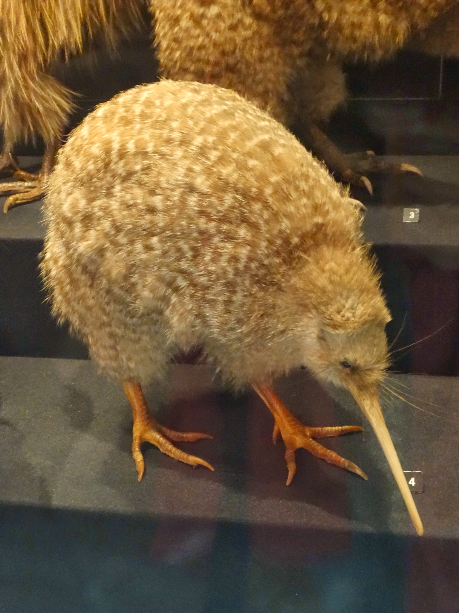
And finally...the closest we got to a kiwi - stuffed and mounted!


Thursday, 13 March 2014

Hoki Koki on the beach and other stories

With difficulties in finding time to write and getting internet connectivity, we are rather behind with our blog. Maybe this was behind one rumour reaching us that we had sneaked back into the UK! Well, we can correct that one - we have currently stopped for a week in the Blue Mountains near Sydney and are taking the time to recover our breath and to update everyone on what we have been up to since our last post.


On Thursday 13th February, we headed out of the mountains of New Zealand's South Island and down towards the south coast. We had been planning to stay in the Catlins, being the southernmost region of the mainland, but it was a bleak day with the rain driving down, so we skirted quickly along this part of this coastline aiming towards Dunedin.

The rain added to the drama of the sea-scapes and we could see why many ships have foundered on these shores. Long sandy surf beaches were interspersed with rugged cliffs and the occasional small town, surviving on a bit of fishing and tourists in season. As we approached the east coast, the landscape became gentler, with rolling green hills dotted with sheep and cattle. We also felt as though we were arriving back into civilisation as the road passed through a few larger towns. These had a rather run-down feel, with rusting old factories that probably served as canneries and other food processing facilities hinting at better days in the past.

Dunedin, when we arrived, had a livelier feel, with it's setting around a wide bay and many well-maintained Victorian era buildings. Our plan though was to stay on the Otago Peninsula, which juts out into the ocean to the east of the city. We eventually found a place to stay on a converted farmhouse at the far end of the peninsula, not particularly luxurious, but with a beautiful setting.

For our first 2 nights, the only other occupant was Julia, who was working locally: currently as a guide at the penguin sanctuary just down the road, until May when she will miraculously transform for 6 months into a ski instructor. On our third and final night, a few more people arrived, including another English Sue, this one taking a break from her time on the British Antarctic Survey - now that's an interesting job!

The Otago Peninsula, was a beautiful, rugged, isolated place and we felt really in our element here. At the very end of the road, we reached some towering cliff tops, where the next stop would probably be the west coast of South America. It's main fame, is that these cliffs are home to the world's only mainland royal albatross colony. We took a short walk to a viewing platform and watched in awe as these majestic birds, with wing-spans of up to 5 metres, glided on the thermals above the cliffs.

Our time, here was mostly about hiking and spotting wild-life. We had the paths pretty much to ourselves and it was like being in the Yorkshire Dales, with the Cornish coast-line spliced on. In addition to the albatross, we spotted seals and sea-lions basking on the deserted sandy beaches and rock pools and all sorts of gulls, terns and other sea birds.

But there was also a lively local community in the small village of Portobello with its pub, shop, chippy and a couple of cafés. Driving back down a steep, narrow lane into the village from one of our walks, we were stuck for a couple of miles behind a local women in a motobility scooter. We got past her eventually, but then bumped into her again 5 minutes later in the village shop: 'ee up luv' she greeted Sue. She was from Yorkshire and 60 years living in Portobello hadn't blunted her accent, but she seemed less than impressed to hear that we were from Kent - we knew we should have run her off the road when we had the chance!
Hiking in the Otago Peninsula...

...with stunning vistas in all directions

The hills are alive...
Nothing better than an itch scratched - a sea lion basks on Allan's Beach on the Otago Peninsula

Back on the road again, we had a long drive day on Sunday 16th February. We were heading back towards Christchurch to complete our 2 week loop around the South Island. Before dropping the car back in Christchurch though, we had a couple of nights pencilled in to stop on the Banks Peninsula to the east of the city. The peninsula was formed 8 million years ago by two huge volcanic eruptions and juts out from the mainland like a mis-shapen bicycle wheel. Again, it is spectacularly beautiful, particularly the road to the centre, which passes over the highest points, with 360 degree views of the peninsula and the ocean below.

We stopped in Akaroa, the main town, which is also now used by cruise liners that used to stop in Christchurch pre-quake. It was a quaint town, full of tastefully refurbished colonial houses and a pier used by pleasure boats for cruises around the bay. It was a pleasant stop, even if it felt rather manicured to us after the ruggedness of the Otago Peninsula.

The area has an interesting history though, which is worth recounting with apologies to our French readers. The area was sighted by James Cook in 1770, but not colonised until 1838 when a French whaling captain took a liking to it. He struck a deal with the local Maori and headed back to France to obtain royal approval and returned in 1840 with 63 settlers on board. Sadly for him, he returned to find that the British had learned of his plans and he sailed back into the harbour to find the Union Jack flying proudly on the headland - the Treaty of Waitingi (between the British and Maori chiefs) had overridden his deal and he and his crew faced the choice of returning to France, or becoming British subjects!

To reflect on what might have been, a small stone plaque has been laid commemorating the first French landing. Oh yes and then there are some French named streets and a couple of bistros that allegedly serve the best food in New Zealand!

View of the Banks Peninsula from the road

The harbour at Akaroa

An Oystercatcher competes with tourists for his favourite morsel

We sadly drove back to Christchurch to drop our car off, because it felt as though the best part of our NZ trip was behind us. We had 4 hours to kill before a bus trip north up the east coast to Kaikoura. Christchurch was experiencing a heat-wave, with temperatures well into the 30s, but as described in our first post 'Quake City' this still felt like a city suffering from post-traumatic shock.

This was amplified by Sue's conversation with a women that came to sit with her on a bench whilst I was getting our lunch. Her home in the city of 50+ years had been destroyed by the quake and shortly after, her husband was diagnosed with terminal cancer. Following his death, she has been re-housed in a small flat outside the centre. Each day, she walks into the city, more out of habit than necessity. She was trying to put on a brave face, but we could sense how lost, lonely and bewildered she was beneath the bravado.

By the mid-afternoon, we were on a bus, for the scenic 3 hour drive up the coast to Kaikoura. It was a novelty not to be driving and I responded by snoozing most of the way! Kaikoura is famous, for it's steeply shelving shoreline, which means that a huge variety of deep-sea creatures can be spotted very close to land, most notably being whales and dolphins.

The town itself was rather bland, just a long strip of shops, bars and fast food joints along a rather scruffy beach, but we made the best of it and on our first evening we got ourselves some fish and chips (Hoki - the local speciality) and a bottle of the local Sauvignon Blanc for which the area is renowned (the Marlborough region is just north of here). We sat on a bench overlooking the beach to eat it as the sun started to set, but were soon surrounded by dozens of seagulls, all hoping for a share of our Hoki. They were to be disappointed, though we had to watch them (pardon the mixed metaphor) like hawks - they had clearly done this before!

We had 2 full days in Kaikoura. The first, we spent on a bracing circular cliff-top walk, looking down on seals cavorting on the rocks below. The highlight though (and one of the highlights of our whole trip) was a boat trip out to 'swim with dolphins'. This is one of the few places in the world, where there is a good chance of swimming with dolphins in the wild and, despite the extravagant claims in the marketing literature, we were slightly dubious as to whether the dolphins would play ball. Our cynicism was misplaced though, because after motoring out for half an hour, we found ourselves in the midst of a pod of some 400 dolphins. Donned in wet suits, masks and snorkels, we got amongst them. They clearly found us most amusing and swum around and under us, close enough to touch and performed acrobatics, jumping out of the water, as if in celebration.

Sadly, we didn't have our camera with us on this trip, but you can see some pictures from similar trips on the organiser's website: www.dolphin.co.nz

So, we come to our last steps on the South Island, which was another bus ride up the coast to Picton. From here the ferries wind their way through the Marlborough Sounds and across the Cook Strait to Wellington. Although we were here primarily to catch the ferry, Picton turned out to be a very nice town with a laid back atmosphere and a beautiful setting. We didn't have much time here, regrettably, but we spent the afternoon of our arrival walking around the bay, where there were fine views out towards the Sound, and I even managed a quick dip in one of the secluded beaches on the edge of town!

The road out of Picton, with views towards Marlborough Sounds

Swimming at Picton

All of this, brings us to Saturday 22nd February. In our next post, we will tell you about the boat across to Wellington and our time in the North Island.

And finally...yes, it's true there are more sheep than people in NZ!

And finally, finally...a cicada - can you believe such a small thing makes such a big noise?!