Sunday 23 February 2014

The Southern Alps

We finished our last post, at the end of the west-coast road, in the lonely, wind-swept Jackson Bay. On Sunday 9th February, we left the west coast behind and cut inland for probably the most scenically impressive drive of our year to date.

The road initially switch-backed up through dense forest, following steep sided river valleys. We stopped occasionally to look at waterfalls, where pure mountain water cascaded hundreds of feet into rivers and streams below. This road was only completed in 1965 (making it the same age as me!), before which the only road through the mountains from east to west was Arthur's Pass which we came through on our drive from Christchurch. We had read about how a Canadian couple had tried to drive through here in a storm and their car had been washed over the edge of one of the gorges by the sheer volume of water pouring off the mountains. This really reinforced how remote this area is, but fortunately the day was dry and sunny and we just enjoyed the drive.

Eventually we climbed out of the pass at about 600 metres altitude surrounded by snow-capped mountains - Mount Cook at 3,745 metres to our left, Mount Aspiring at 3,035 metres to our right. As the road hit its highest point, we looked down to a series of stunningly blue glacial lakes. First was Lake Wanaka which we followed for 50 miles or so, to our lunch spot of Wanaka: anyone visiting here, should watch out for the seagulls - one snatched half a meat pie clean out of Sue's hand as we sat and ate by the side of the lake!

But the best was still to come, as we continued south to Queenstown and then followed the road north and west along Lake Wakatipu to the small town of Glenorchy. This has regularly been voted amongst the 10 most scenic drives in the world. Words don't do it justice, so judge for yourself from the pictures below.

The drive along the shore of Lake Wakatipu from Queenstown to Glenorchy

We had decided to give Queenstown a wide berth and continue onto Glenorchy, partly because we had heard about how beautiful the drive was and partly because it was reputed to be much quieter. We were right, because Queenstown does adventure tourism on an industrial scale. It's the base for bungi jumping, canyoning, white-water rafting, rock-climbing, hang-gliding, helicopter-hiking, jet boating and multi-day alpine hikes - all on a more extreme level than almost anywhere in the world. With all that adrenaline pumping, the bars and night clubs are also allegedly wild and go on through to dawn without abating.

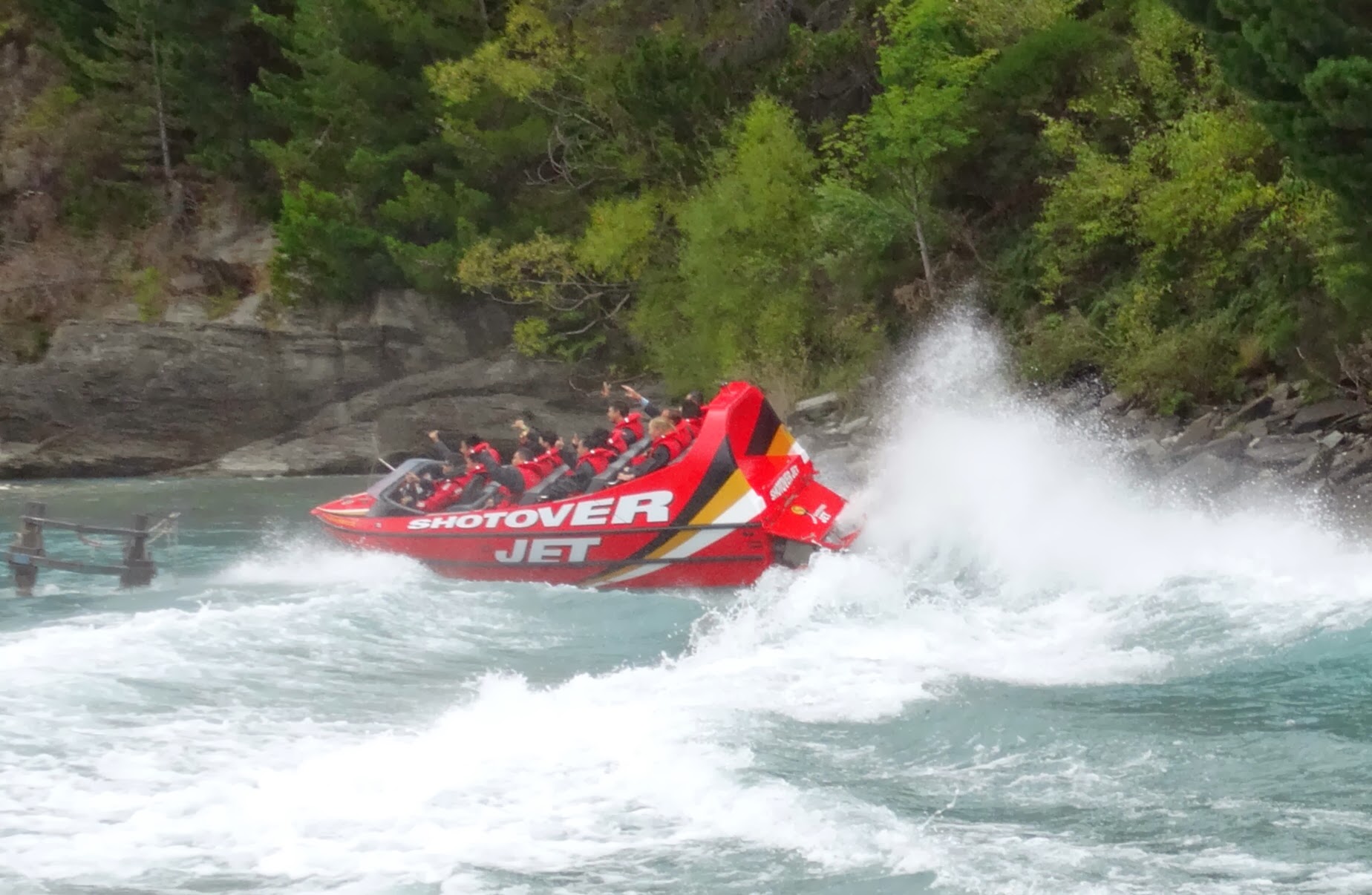
OK, we're showing our age now, but we couldn't cope with all that! I couldn't ignore it altogether of course, so I picked one activity: the white knuckle 'Shotover Jet'. These boats have 2 engines that produce 700 hp and can travel at more than 50 mph. The drivers seem to take great pleasure in taking the boat to its max: hurtling through a narrow 6 mile stretch of the Shotover Creek Canyon, sliding round corners inches from the canyon walls and spinning 360 degrees to a stop! The margin for error seemed minuscule, but the drivers knew every inch of that river and could probably do this blind-fold.

This was probably the closest I have ever seen to a money-mint: people were queuing to hand over their $129 and they turned us over with incredible speed and slickness; two 12 seater boatfuls going out every 15 minutes; all arriving back with big grins and leaving via the gift shop to buy souvenirs. And yes, every boat is fitted with cameras front and back, plus cameras on route with triggers set: and by the time you are back in the shop, a professionally produced video and still-photo package is ready for you to buy and take away!

We were far too cynical to part with any more money, but I have to say it was a really exciting experience. Sue didn't fancy it, but fortunately she was waiting at the start/finish to capture events - before, during and after!

Jet boating in Queenstown: before...
...during...
...and after!

Glenorchy was a million miles from the raucous Queenstown. Nestled at the top of Lake Wakatipu, it is a small oasis of farmland, surrounded by water and mountains and home to just a few hundred people. We stayed for a couple of nights in a cabin in a quiet holiday park, but could easily have stayed much longer.

Lake Wakatipu viewed from Glenorchy

Just north of here, is the start of the Routeburn Track - one of New Zealand's greatest alpine walks, cutting through mountains where roads can't reach for 32 kilometres and taking up to 4 days to traverse, weather permitting.This was too much for us, but we managed a good 3 hour hike on the 'Invincible Gold Track' instead. We took the car as far as we dared (the road became so rutted, that we thought the car would be shaken to pieces) and then headed sharply upwards, on a trail that ran through thick forest, occasionally rewarding us with great mountain views. We finished up near one of the peaks, at the site of an old gold-mine where some of the old machinery, used to crush and process the base quartz, still remained rusting away. We also found evidence of old prospector houses and again thought how remote and spartan their lives were: Glenorchy was a 20 kilometre hike away and the only way onwards from there was the bi-weekly steamer on to Queenstown.

Hiking the 'Invincible Gold Track' near Glenorchy

It was interesting to note that there had been plans to extend the Quenstown to Glenorchy road onto Milford Sound. At the moment, the only way to do this by road, is a 180 mile trip around the mountains and lakes. The proposed new road would have involved much destruction of ancient forest and tunnelling through rock and a constant stream of tourist traffic plying the route thereafter. New Zealand has a very strong environmental lobby, which has stopped a number of similar projects and ultimately the plans were dropped. Whilst we were here, a new proposal had recently been raised for a mono-rail train to run the same route. There were petitions running in nearly every shop and cafe we visited and we suspect that this will be similarly defeated - good on the Kiwis we say for holding onto their principles and recognising how precious these pristine wildernesses are!

We very happily drove the 180 miles on our next leg, with the scenery remaining stunning all the way. We broke our journey in Te Anau, a small town at the southern tip of the lake of the same name (and New Zealand's second largest). This was the site for one of the first environmental battles, when plans came out in the 1950s to built a huge hydro-electric power station on the western side of the lake, which would have resulted in the flooding of some environmentally sensitive areas on the edge of the Doubtful Sound Fiords. The protests were heard loud and clear and the government eventually approved a much reduced project wth no effect on water levels.

Te Anau is the last stop before the wonderful Milford Sound and we made a day trip of it. The 75 mile trip each way is another of the world's great scenic drive. It starts promisingly enough, hugging Lake Te Anau and rising steadily through native rain-forest, but the best is saved for the last 20 miles, when the road heads through a narrow pass in the granite mountains, which jut sharply up for hundreds of metres on either side of the road. It is referred to in one of the brochures as an 'ice-carved amphitheatre' which describes it perfectly. On our chosen day, it was raining steadily as we headed up, which sounds like a real spoiler, but it only added to the atmosphere as the rain poured off the mountains in a series of waterfalls. At the top, the road appeared to run out, but we had simply reached the Homer Tunnel - where there was no other option but to blast through the mountain - nearly a mile to the other side. We sat and waited for our turn, the entrance being controlled by traffic lights, as it's single lane all the way!

Whilst we waited, we found out some more about New Zealand's second most famous bird - the kea, a native parrot. We had spotted a few of them from a distance on our travels. Here they were in their element and bizarrely we found they had a taste for rubber - one landed on our wing mirror and started to try and eat our door trim, a trick it's cousins were repeating on other cars in the queue!

The Kea - king of the New Zealand mountains...

...and with something of a rubber fetish!

The dramatic, mountain road from Te Anau to Milford Sound

But if we enjoyed the drive, the best was still to come, with a two and a half boat trip out from Milford Sound, ou through the magnificent Fiords and to the mouth of the Tasman Sea. We had picked a small company to go with, which proved a great pick as there were only a dozen of us on the boat and our trip started as most of the bigger boats were finishing up. We started with a geology lesson: a 'Sound' is formed by river erosion and, whilst this area is called Milford Sound, it was formed by glacial erosion and is therefore technically a 'Fiord'. The European settlers naming it realised their mistake too late and corrected the error later by naming the whole area 'Fiordland'!

Whatever it is called, it is magnificent and we sailed out through the calm waters with Mitre Peak and the other mountains rising majestically straight out of the water, their peaks appearing and disappearing enigmatically through their clouded shrouds. We sailed through sun, then rain and then sun again and rainbows appeared in celebration as we passed through the showers. Seals basked on the rocks as we passed and to crown it all, a pod of dolphins joined us swam with us for 20 minutes as we headed back for port - a rare occurrence the crew told us.

The magnificent Miford Sound (technically a Fiord not a Sound)

A seal basks on the foreshore of Milford Sound

Under the Rainbow...Milford Sound

That's all for this post. Next time, we will tell you about how we completed our circuit of the South Island back to Christchurch.


Sunday 16 February 2014

Gold 'n' Glaciers

After a couple of nights in Christchurch, we were able to start our exploration of New Zealand's South Island in earnest. Before arriving, we had no plan, other than to pick a small rental car up on the morning of Wednesday 5th February and see where the road took us - a refreshing change from the military precision with which we'd planned our journey from Europe down through Asia to Australia.

Still, we realised that without some sort of plan, we could miss some highlights, so the night before departing, we came up with a rough itinerary: a clockwise loop down the east coast, across to Fiordland in the south-west and then up the west coast, before heading back to our starting point through one of the few alpine mountain passes.

After a couple of days of beautiful weather in Christchurch, we awoke on the Wednesday morning to rain and a biting easterly wind. A quick check on weather forecasts suggested that this was probably set in for a few days, whilst the weather on the west coast was sunny and 5 degrees warmer (a reversal of the more usual pattern apparently), so with a moment of decisiveness, we decided to reverse our route. This proved a great decision, because we had mostly great weather on our jaunt down the west coast, whilst the east was cold, wet and windy (though nothing on the scale of the poor old UK - we hope that all of our British readers are dry and safe).

So, we headed out of a cold, wet Christchurch and headed due west through farmland that steadily rose towards snow-capped mountain peaks. This road was originally built by European settlers, when gold was discovered in the western foothills: initially no way was found through the Southern Alps, until a prospector found his way through following old Maori routes and the dramatic Arthur's Pass continues to be named after him. As we came over the pass, we could see the line of the cold front, with clear blue skies in the distance toward the coast - an island of two halves indeed!

The west coast is wild and rugged, with a thin coastal strip between the mountains and the Tasman Sea and bordered to the south by the Fiordland wilderness. Maori people travelled up and down this land for thousands of years, making good use of the bountiful fishing and trading the prized jade stone. The early European settlers found the going much harder: with the coast battered by storms from the Tasman Sea, heavy rainfall for much of the year and the natural isolation from the rest of the country. Some areas boomed when gold was discovered in the 19th century, but fell into decline just as quickly as it was mined out.

Notwithstanding all of this, we were astonished to find that this 500+ mile long strip is populated by just 32,000 people, though this is swelled many times over in the peak holiday season.

For us, this was a truly spectacular place to drive through and it certainly matched up to its reputation and our expectations. In Christchurch, we had bought a tent and we used this for a few nights on this first leg of our New Zealand tour to allow us to stay in some remote and beautiful places. After hitting the west coast at the village of Hokitika, we camped by the side of Lake Kaniere - alongside some guys from Sheffield trying their hand at trout fishing, a couple from Washington DC and some locals who used the lake for their speedboats.

Better was to come as we headed south though, as the next night we found a great camp site within view of the Franz Josef Glacier.

The first outing for our new tent by the side of Lake Kaniere

The view from our tent of the Franz Josef Glacier

The twin glaciers of the Southern Alps (Franz Josef and Fox), deserve some mention. At this point, Mount Cook (New Zealand's highest peak at 3,754 metres) falls sharply towards the coastal plain and with such high levels of precipitation on this coast, these glaciers form - sliding dramatically towards the valley floor at the rate of more than a metre a day. They are a wonderful sight, resembling an eruption of volcanic ice, or a waterfall suddenly frozen in full flow. Sadly, with global warming these glaciers are steadily retreating and with current trends, they will probably be gone altogether within our lifetimes.

We spent 2 full days here, hiking up to the base of each glacier - at elevations of about 1,500 metres. Both were great walks, with the vistas improving each time we rounded a bluff. There was a small stream of other people walking up with us, but generally nothing to spoil the serenity of the scene, other than the regular buzz of helicopters, whisking people up over the glacier for a $350, 20 minute joy-ride - we weren't tempted by that offer!

A view of Franz Josef Glacier from the base

Ice hiking on Fox's Glacier

A long distance view of Franz Josef, with a back-drop of Mount Cook

A mirror view towards the Fox Glacier

Away from the mountains, by the coast, we found the old gold rush town of Okarito. At its peak, 10,000 people were based here seeking their fortunes and there were dozens of hotels, bars, shops and other amenities - it must have been a wild place! Today, all evidence of this has vanished, other than some old photos on display in a preserved wharf building, and it is little more than a hamlet with a handful of houses overlooking a windswept bay and lagoon. It was the latter which prompted our stop, because it is apparently the largest unmodified wetland in New Zealand and home to all manner of bird-life.

I took a kayak out onto the lagoon for a couple of hours, getting up close to a variety of hawks, herons, oyster-catchers, plovers, stalks, shags and terns (though sadly not a kiwi, which are found in this area, but are nocturnal). This was a beautiful and serene way to explore the area, paddling in still silence, across the lagoon, with dense native forest and mangrove hugging the shoreline and the towering Mount Cook and the glaciers in the background.

Sue decided to take the land route instead, walking around the lagoon and along the beach and she had lots of information to pass on when I returned. Most exciting, was that this was the home of Keri Hulme, the Booker Prize winning author of The Bone People (a novel which inspired Sue in her late teens). The Bone People had a very strong, and evocatively described, sense of place: and we could both feel how this place could have inspired that.

The guys who ran the kayak centre were a great bunch and we sat and drank coffee with them for a while. Often people in tourist areas aren't interested in communicating beyond a superficial, practical level, but we could easily have spent the day here chatting with them. Amazingly, one of the women who ran the place had spent a year or so in the UK, with much of that time financed by bar tending at the White Hart in Brasted - one of our local pubs!

A shag on Okarito Lagoon

We continued, with a long drive south following the coastline. The skies were clear and we were treated to one spectacular view after another: sometimes close to the water's edge past deserted stretches of sandy beach, sometimes from high above over precipitous cliff tops.

One of many beautiful vistas on our drive south

We were heading towards Queenstown, but we broke our journey for the night in the hamlet of Haast, where there wasn't much apart from a few motels and a lively bar which served up decent pub grub, mostly to tourists like us. We were intrigued to follow an extension of the road to the village of Port Jackson, which really is the end of the line: nothing beyond here but fiords and then the Antarctic. The road to Port Jackson was terrific: dead straight through ancient forest, with tree species that we had never seen before. It felt as though we had been teleported back to the 'land that time forgot' and that dinosaurs would poke their heads above the canopy at any moment!

Port Jackson was an eerie place, with a small cluster of houses and a rotting, rusting pier which looked like the next good storm would bring down. At the end of it, a sullen local, bearded and hooded, was fishing for salmon or anything else that would bite (though the only things that seemed to be biting were the voracious sand flies who were having a feast on us). 'You from the UK?' he asked mid-cast. When we answered in the affirmative, he divulged that he was a 5th generation Cornish immigrant. We might be related, I thought, but he didn't seem much of a conversationist, so we left him to his fishing and headed back to the insect free sanctum of the car.

The next day, we cut inland into the heart of the Southern Alps. In our next post, we will tell you all about this: including the adventure centre of Queenstown and it's surrounding villages; the magnificent Fiordland and our route through all of this natural wonder.


Wednesday 12 February 2014

Quake City

From Kentish Downs to Southern Alps: on 3rd February, we were hugely excited to be on the way to visiting the 16th country of our tour and the furthest from home. In our first post, we admitted to feeling a little like hobbits on the way to Mordor; now we were arriving in the country chosen to film said Tolkien sagas!

Before starting this leg of our adventure in earnest, though, we first had to confront a nightmare that has been largely forgotten by the world: the tragedy of the Christchurch earthquake. On 22nd February 2011, the Cantabrian earth shook and 185 people died as buildings collapsed around them. Still, one doesn't appreciate the scale of such an event until one has been there. Three years later, we were shocked to see the extent of the devastation wreaked and how the city is still struggling to cope with, and recover from, the aftermath.

We probably had the impression that only fairly small area was badly affected. How wrong we were. The Central Business District was, and remains, devastated, but we saw significantly damaged buildings in a radius of several miles. We could see what a beautiful city that Christchurch was. The Avon river, still meanders gently through it, bordered by lush meadows and weeping willows. But the once proud cathedral spire has crumbled, the remains grimly clinging to scaffolding like a punch drunk boxer. Nearly all of the main buildings in the centre either came down in the quake and it's after shocks, have subsequently been demolished, or stand eerily boarded and fenced awaiting demolition or repair. We trudged in disbelief through the centre of a city still swathed in dust and eerie silence.

After 3 years, we had expected that the city would have returned much more towards normality than this, but the complete rebuilding of a city will take much longer yet. The practicalities are endless: helping people through their immediate problems: assessing the damage; closing off dangerous areas; providing short term shelter; re-connecting power and sanitation facilities (a huge job in itself, as much of this infrastructure was destroyed or damaged); demolishing; creating new plans; ensuring that there is a framework to do all of this in a co-ordinated manner; obtaining finance and only then starting the process of rebuilding.

There are some signs that a Phoenix is starting to emerge from the ashes, such as the main shopping street which was largely flattened but has started trading again from make-shift portacabins and converted shipping containers. How much longer though to repair it's damaged spirit? The people that we spoke to seem to be pretty phlegmatic and the economic and social activities of the city seem to have simply moved from the centre to the suburbs, but our view is that a city like Christchurch (with 400,000 people and the only sizeable city on the South Island) needs and deserves a heart. So, our sincerest best wishes go out to the people of Christchurch that they can rebuild and revitalise their once beautiful city.

We will finish this post on that note and next time fill you in on the wonderful alpine scenery that we have started exploring here.

 
Business, government, the church - nothing was spared by the power of the earthquake

Demolition and rebuilding work in progress

The main shopping street trades again...from converted shipping containers

A reminder of a more serene Christchurch in the botanical gardens

And finally...the tram doesn't stop here anymore


Monday 3 February 2014

Sympathy for the (Tasmanian) devil

Please allow me to introduce myself...can you guess my name?!

This posting sees us reach our furthest point south. On 24th January, we flew from Melbourne to Hobart in Tasmania and as we looked out to sea from there, we knew that there was nothing between us and the Antarctic.

We had read a lot about the shameful history of the settlement of the island and approached with some trepidation as to how we would feel the imprint of this. For those who don't know the history, Tasmania was one of the earliest parts of Australia to be settled by Europeans and probably the region which had the greatest conflict with the Aboriginal population. The culmination of this was that the Governor General of the time approved a policy of hunting them down. This led to an operation known as 'The Black Line', where the settlers literally formed a line to sweep the island, killing or capturing any Aboriginals that they could find. The objective was to exterminate them from Tasmania - the small numbers captured were sent to an offshore island, where most of them died from disease or the hardship endured.

It is still debated whether any 'pure' Tasmanian Aboriginals survived, but most think that at least some did and pleasingly there remains today a burgeoning Aboriginal culture in Hobart. We were in Hobart for Australia Day, which marks the anniversary of the arrival of the first fleet of British ships. Many Aboriginals still treat this as a 'day of mourning', but overall our impression was that there is a mood of reconciliation in the air and a desire to move forwards rather than dwell on the past.

We only had a week in Tasmania, which proved to be not nearly enough, but a thoroughly enjoyable week nonetheless. Our time in Australia to date had been mostly urban based, so here we went for some nature therapy: staying for 3 nights in the small country town of New Norfolk, on the banks of the Derwent River; 2 nights in a farm in Deloraine, a small town on the edge of Cradle Mountain National Park and 2 nights in Swansea - no, not that Swansea, this one had glorious views out over Oyster Bay and the Freycinet National Park and not a coal mine or steel works in sight!

We started our week off with a Saturday morning in Hobart, where the lively Salamancer Market was in full swing. We sat in the warm sunshine by the harbour eating freshly landed oysters ($7 for half a dozen, a rare Aussie bargain) and Scallop Pie (a local speciality, baked in a lightly curried creamy sauce), washed down with a chilled cup of Tasmanian Sauvignon Blanc.

Not enjoying those oysters at all!

Hobart has a great setting, with its colourful bungalows and town houses scattered around the natural harbour and Derwent river valley and reaching out up the slopes of Mount Wellington and Mount Nelson. A road switchbacks 1,500 metres up to the top of Mount Wellington and we lurched the full course in our boat of a car hire. The views from the top were magnificent, but it was one to be admired briefly, because it was bitterly cold up there with nothing to stop a brisk Antarctic wind and to add to this, it started to sleet as we got out of the car!

The view of Hobart and beyond from atop Mount Wellington

Our home for 3 nights was a charming whitewashed timber framed colonial building, with a large English style garden. It was run by a couple of ex-pat South Africans who made us very welcome and we were able to sit drinking tea in their peaceful conservatory, chatting with the other guests. Robert, an Englishman on holiday was in town to watch the ladies cricket - but we're sad to report that even the English ladies are losing to Australia this year!

We also used this as our base to look around the Tasman Peninsula in the far south east of the island. It is almost cut off from the rest of the island by the wonderfully named causeway Eagle Hawk Neck. The area was infamous as housing one of Britain's first penal colonies at Port Arthur and Eagle Hawk Neck was populated by savage dogs at this time to deter the convicts from thoughts of escape. These days, the isolation is being put to a better practical application. Tasmanian Devils are endangered by a combination of habitat loss and an infectious facial cancer (apparently 'devil foreplay' includes sinking those fangs into each other's faces!), so the Tasman Peninsula is being used to isolate healthy animals.

It was good to hear an environmental good news story, because the new Australian government appears to be running roughshod over what had been reasonably enlightened policies. We were horrified to hear 2 such stories whilst we were here: firstly it has passed a special resolution to allow 3 million cubic metres of dredge spoil to be dumped into the Great Barrier Reef National Park in order to allow better export access for a coal mine in Northern Queensland; secondly they have applied to have 74,000 hectares of Tasmanian World Heritage listed, slow growth, ancient forest to be de-listed, so that commercial logging can extend into the area. This seems tragic to us and a terrible example for an affluent society to be setting - putting short term commercial gain ahead of long term environmental protection. We hope that this application will be rejected by the World Heritage body when it meets.

But enough politicising. From Our base in New Norfolk, we headed north for a long driving day, taking in a wide circuit of the Cradle Mountain Lake St Clare National Park. Our route took us up through some of the wonderful aforementioned forests (filled with huon pine, tall eucalyptus, pre-historic looking 'fern trees' and other indigenous Tasmanian flora), past steely blue lakes surrounded by jagged mountain peaks and onto Strahan (a sleepy fishing port / tourist town and the only significant town on the west coast of Tasmania) before heading east for our farm stay in Deloraine on the edge of Cradle Mountain and the Western Tiers.

Deloraine was a peaceful stop for a couple of nights. The owner of the farm emigrated to Australia from Northampton when he was 14 and is shortly to retire from the business with his wife who runs the B&B and travel around Australia in an RV. He took us out one evening to an area at the back of the farm favoured by wallabies and we spotted several of them hopping around in the fields on the edge of the tree-line. We had one full day in the area, which we spent in the Cradle Mountain Park and did a great 3 hour hike around Lake Dove, with stunning views of the mountain and the area around.

A view of Cradle Mountain, with Lake Dove in the foreground.

Our final stop was intended to be in a country inn by the side of a lake, but we arrived to find the place closed - it seems they hadn't got our booking and decided it wasn't worth opening! No matter, we carried on to the east coast to the village of Swansea, which we used as our base for exploring the Freycinet National Park. Here, we did another fantastic hike climbing through forest to a ridge and then descending down to Wine Glass Bay, by all accounts one of the most beautiful beaches in Australia and only reachable on foot or by boat. Take a look at the picture - we're not sure you'll spot many beaches better than this anywhere!

After the beautiful, serenity of Tasmania, we headed back to Melbourne for a couple of days, staying on the southern edge of the CBD and meeting up for lunch with Sue's cousin Steve and Jane, before catching a morning flight on Monday 3rd February for Christchurch. We're really looking forward to spending a month in New Zealand, but we will tell you about our first impressions of the South Island in our next post. In the meantime, we will leave you with some pictures of the wonderful wildlife that we spotted in Tasmania.

A poteroo - one of the smallest marsupials and almost too shy for the camera!

Spiky, but still cute - an Echidna!

And finally...don't mess with me, I'm a Wombat!